The ChiliView Series - Boulder (KBDU) The ChiliView Series - Boulder (KBDU)
More screenies:
Prev
Next
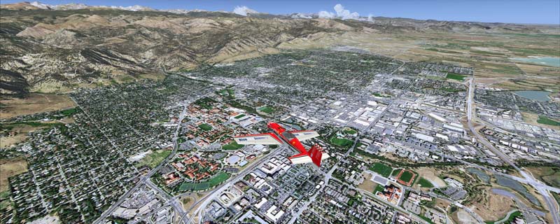
This scenery covers the Boulder - Longmont - Loveland area. Boulder is situated in Boulder Valley, where the Rocky Mountains meet the Great Plains. Just west of the city are imposing slabs of sedimentary stone tilted up on the foothills, known as Flatirons. Located at the base of the foothills is Boulder's main campus of the University of Colarado which is clearly visible from the sky. Longmont is home of the Denver ARTCC (Air Route Traffic Control Center) which controls all flights in the upper airspace of most of Colorado and parts of adjoining states.
The adapted airports for this area are available in the collection of all airports provided by Joop Mak: BSS_AFCADs_0718.zip.
It covers a total of 3625 sq km.
For FSX and Prepar3D.
The resolution of 1 m/pix brings you razor-sharp images even near the ground.
Best enjoyed in low and slow operations!
Navigate to neighboring regions:
North
South
West
|
!!! BlueSkyScenery needs YOUR help !!!
If you like our sceneries, then please give a little donation.
Your donation makes a difference and helps us to continue this project!
|
Give $1.00:
|
|
|
Give $5.00:
|
|
|
Give $10.00:
|
|
|
Give $20.00:
|
|
Download:
|
FS9 Version:
|
Scenery
|
Airports
|
| |
|
For FSX & P3D:
|
Scenery
|
Airports
|
Scenery Mirror
|
You can support the freeware project by visiting our sponsored links:
|
|
|
All information on this site strictly for simulation use only!
All Trademarks copyrighted. (c) by BlueSkyScenery. All rights reserved.

|
|
|