The ChiliView Series - Death Valley National Park Central, Furnace Creek (L06) The ChiliView Series - Death Valley National Park Central, Furnace Creek (L06)
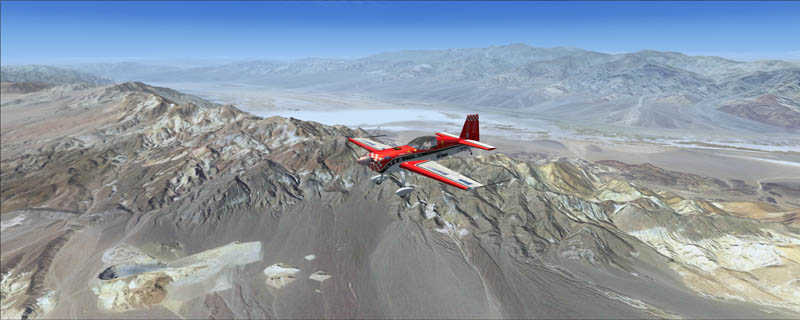
This region covers the central part of Death Valley National park which is the hottest and driest of the national parks in the US. Summer temperaturs of 120°F are common and the highest temperature ever recorded was 134°F! Badwater Basin, which is 282ft below sea level is the lowest point in the US and another fine example of an endorheic basin where the water does not flow out through rivers but may only leave by evaporation. After significant but very rare rainstorms the valley floor is covered by a thin salt lake. But this does not last for long because the 1.9 inches of average annual rainfall are overwhelmed by a 150 inch annual evaporation rate. So even a 12ft deep lake would dry up in a single year. After the water evaporates the dissolved salt remains and forms a salt pan which is clearly visible from the air. Furnace Creek Airport (L06) is located on the valley floor and at -210ft, it is the lowest elevation airport in the US. West of the valley you can fly around Telescope Peak (11.043ft) which rises impressively above the valley floor at -282ft.
It covers a total of 3625 sq km.
For FSX and Prepar3D.
The resolution of 1 m/pix brings you razor-sharp images even near the ground.
Best enjoyed in low and slow operations!
Also contains a 10 m high resolution elevation mesh.
Navigate to neighboring regions:
North
South
East
West
|
!!! BlueSkyScenery needs YOUR help !!!
If you like our sceneries, then please give a little donation.
Your donation makes a difference and helps us to continue this project!
|
Give $1.00:
|
|
|
Give $5.00:
|
|
|
Give $10.00:
|
|
|
Give $20.00:
|
|
Download:
|
FS9 Version:
|
Scenery
|
Airports
|
| |
|
For FSX & P3D:
|
Scenery
|
Airports
|
Scenery Mirror
|
You can support the freeware project by visiting our sponsored links:
|
|
|
All information on this site strictly for simulation use only!
All Trademarks copyrighted. (c) by BlueSkyScenery. All rights reserved.

|
|
|