The ChiliView Series - Glacier Park National Park, Babb (49S) The ChiliView Series - Glacier Park National Park, Babb (49S)
More screenies:
Prev
Next
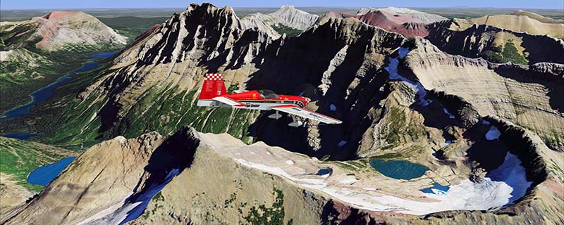
The mountains of Glacier National Park began forming 170 million ago. Then much later, during the Pleistocene Ice Age (from about 2 million years to 10.000 years ago) huge glaciers carved the mountains into their present shapes. During this time the lower valleys were filled completely with glaciers and only the very tops of the higher peaks were visible. Glaciers are not static but they "flow" because of their own weight pushing them downward. The speed of this flow varies greatly, but is typically around 3 feet per day. These "rivers of ice" sculpted the mountains and valleys into a variety of landforms. Approx 10.000 years ago the glaciers melted away and left massive u-shaped valleys, numerous cirque lakes, spectacular horns, cols, moraines, and aretes. Today there are just about 37 small alpine glaciers in Glacier Park. They are of relatively recent origin, having formed in the last 6.000 to 8.000 years. However, they work in the same way as larger glaciers of the past.
With this scenery you can fly to breathtaking views and see the whole park, of which only a fraction can be seen by road or trail! To explore the scenery depart from the small strip of Babb (49S) and head west. In the north the scenery ends right at the Canadian border.
It covers a total of 3625 sq km.
For FSX and Prepar3D.
The resolution of 1 m/pix brings you razor-sharp images even near the ground.
Best enjoyed in low and slow operations!
Also contains a 10 m high resolution elevation mesh.
Navigate to neighboring regions:
South
East
West
|
!!! BlueSkyScenery needs YOUR help !!!
If you like our sceneries, then please give a little donation.
Your donation makes a difference and helps us to continue this project!
|
Give $1.00:
|
|
|
Give $5.00:
|
|
|
Give $10.00:
|
|
|
Give $20.00:
|
|
Download:
|
FS9 Version:
|
Scenery
|
Airports
|
| |
|
For FSX & P3D:
|
Scenery
|
Airports
|
Scenery Mirror
|
You can support the freeware project by visiting our sponsored links:
|
|
|
All information on this site strictly for simulation use only!
All Trademarks copyrighted. (c) by BlueSkyScenery. All rights reserved.

|
|
|