Scenic flight from Long Beach to Van Nuys
Today we will do a scenic flight from Long Beach (LGB) to Van Nuys (VNY). This VFR flight will lead us over highly diverse scenery including the beautiful Palos Verde Peninsula, urban areas like Long Beach and directly over Los Angeles International airport. The information in this story is strictly for simulation use only. DO NOT
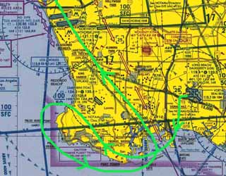
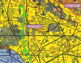
use any information for real world flying! That's our route, drawn in the LA terminal area chart:
The following freeware sceneries and charts will make our flight as real as it gets.
- Los Angeles north and south sceneries
- Long Beach and Van Nuys airport area sceneries and taxi diagrams
- Los Angeles terminal area chart (important info about airspace layout and reporting points)
- Optional: Los Angeles Int. and Santa Monica airport area sceneries (makes overflying much more fun)
- Optional: Downtown Long Beach scenery (for overflying as well)
You can find the links to all resources on my project homepage: http://www.blueskyscenery.com.
We will use the default Cessna 172P for this flight. RealAir Simulations provides a highly realistic upgrade for the flight dynamics of this aircraft as freeware: ras172_fs9.zip. If you want it even more realistic, fly online! Nothing beats voice communications with real human controllers! For more info go to http://www.vatsim.net.
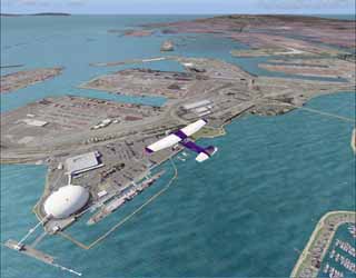
OK, lets start now! It's perfect VFR weather with a little wind from 220 degrees at 4 knots. Visibility is 8 miles with clear skies. We won't start our flight right from the runway but from a realistic parking position. Every flight starts with a good FBO, and so we are filling up our tanks at Signature Aviation. Signature is located on the south ramp just south of exit F-2.
After the runup we contact ground for taxi: "Long Beach ground, good afternoon, Cessna 330DG parking Signature Aviation, request taxi to the active for departure to the south with information Delta". Ground gives us RW 25L for departure: "Cessna 330DG, good afternoon, delta is correct, taxi to RW 25L via Foxtrot, Foxtrot 1, Juliett 1, and Juliet". We pull out the taxi diagram and try to find our way to RW 25L. As we reach the RW we stop at the hold short line. Transponder on and set to VFR squawk code 1200. Landing lights and strobes on now as well because we want to be seen. At this time ground hands us over to tower: "Cessna 330DG, contact now tower on 119.4, good day".
Departure
Next we call tower for our takeoff clearance: "Long Beach tower, good afternoon, Cessna 330DG holding short RW 25L ready for crosswind departure to the south". Tower clears us by: "Cessna 330DG, left crosswind departure to the south approved, leave my airpace via Queen Mary at or below 2.500 feet, cleared for takeoff RW 25L". After our readback we make sure that there is no conflicting traffic on final or on the runway because we absolutely don't like any bent metal. Then we enter the runway.
Smoothly and continously we apply takeoff power. A glimpse on the instruments verifies that our airspeed is rising properly. At 55 KIAS we pull gently on the yoke and off we are. During the climbout we settle for the optimum rate of climb speed of 75 KIAS and make sure to stay on RW heading.
After reaching 700 ft (300 ft below the traffic pattern altitude) we can start our 90 degree left turn to the crosswind leg. On the crosswind leg we take care to level off at the traffic pattern altitude of 1.000ft. To our left we can see now Signal Hill which was used by the local Tongva Indians for signal fires that could be seen throughout the surrounding area and even out to Catalina Island. Later Signal Hill was a productive oil field. Today most oil wells are gone and Signal Hill is now a mix of residential and commercial areas.
After leaving the pattern we pull up slightly and retrim for a 500 ft/min climb to 2.500 ft. Next we are passing downtown Long Beach.
A few degrees to the right and we are heading toward the Queen Mary which is drawn as a reporting point in the terminal area chart. The Queen Mary was permanently moored in Long Beach after her retirement in 1967. Today she serves as a hotel, museum and tourist attraction. She is said to have ghost on board. Many areas are said to be haunted. People report hearing little children crying in the nursery room and a mysterious splash noise in the drained first class swimming pool. In 1966, 18 year old fireman John Pedder was crushed by a watertight door in the engine room during a drill. His ghost is said to haunt this area.
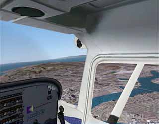
The Queen Mary is now below us and Long Beach tower waves us goodbye: "Cessna 330DG, you are leaving my airspace, resume own navigation, frequency change approoved, good day". We switch to UNICOM and are now left to our own devices. As long as we don't enter any controlled class B, C, D or otherwise restricted airpace we can go wherever we want. Below us unfolds the vast harbor area of Long Beach. We settle for a 85 KIAS climb to 4.500 ft which is well below the LAX class B floor as well as above any class D airport airspace. Vincent Thomas bridge is now in front of us. As long as we are below 2.400 ft we remain well south of that bridge to avoid Torrance airspace which is at our 2 o'clock position. Every 500ft or so we slightly lower the nose and look for conflicting traffic. At 4.500 ft we level off, accelerate to 90 KIAS and throttle back to maintain that speed for optimum fuel efficiency.
Enroute
Speaking of airspaces there is one big obstacle on our way to Van Nuys: Los Angeles Intl. class B airspace. Normally we would need a clearance from SoCal approach to transit this airspace. Fortunately there is an exception - the Los Angeles Special Air Traffic Rules Area. The "corridor" as it is called goes along the 132 degree SMO VOR radial. It is flown at 3.500 ft in SE and 4.500 ft in NW direction. But we won't go directly to the transition. First we make a little excursion to the west and take a look at the beautiful scenery of the Palos Verde peninsula. We pass Vincent Thomas bridge which is to our right and see the white Palos Verde radar domes ahead.
The green stretches of Rancho Palos Verde are a welcome diversion in all this urbanity. We are now well above the ceiling of Torrance airspace which is at 2.400 ft but we must be careful not to bust the floor of LAX class B which is close above us at 5.000 ft and just north of Palos Verde. The big jets perform their departure turns in this area. No place to be for a small aircraft.
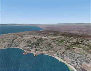
Overhead Palos Verde Point, we do a 180 degree left turn and head back along the pretty coastline towards Long Beach harbor. During the turn we start our descent to 3.500 ft for a proper eastbound VFR altitude.
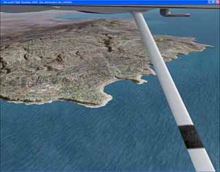
We are heading east now and can clearly make out Point Vicente to our left. Point Vicente lighthouse is situated atop the beautiful Palos Verde cliffs which are rather unique for the LA-area. This place has ghost stories of its own. A mysterious woman in white who commited suicide while waiting for her husband to return from an ocean voyage is said to haunt this place.
Overflying LAX
In preparation for the transition we dial 110.8 into NAV1 and set the OBS to 312 degrees. The needle shows that we are still west of the 132 radial. We fly along the coastline and watch the VOR-needle to become active somewhere over Long Beach harbor. Shortly before the needle centers we turn to 312 degrees and apply more power to climb back to the proper transition altitude of 4.500 ft.
During the transition we have to switch our transponder to 1201 and are encouraged to make position reports. Now we see Los Angeles Intl. Airport in the distance and watch the big jets come and go. The transition leads us right over the airport. It's an absolutely fascinating view.
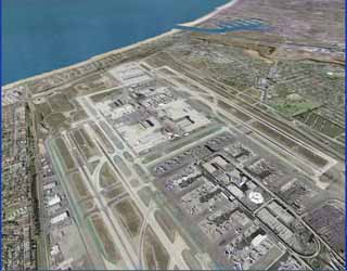
After leaving class B airspace at the north side of LAX we switch our transponder back to 1200 and turn slightly to the east to overfly Santa Monica midfield. On our left we can see now Marina del Rey, which is home to ICANN, currently the closest thing the Internet has to a governing organization.
It's time now to give a call to Van Nuys tower: "Van Nuys tower, good afternoon, Cessna 330DG, 15 miles south of the field, heading north at 4.500 ft for landing". Tower responds: "Cessna 330DG, good afternoon, make a left downwind for RW 16L, report Mulholland & 405 Freeway, Van Nuys altimeter is 2992".
Descent
Now let's plan our descent into Van Nuys. We are at 4.500ft. Van Nuys traffic pattern altitude is at 1.800 feet. That's a difference of 2.700 feet. Multiply the thousands (2.7) by 3 and you get 8.1 miles for a 3 degrees descent. Add 1 mile because we never want to descend into the pattern. So we get 9.1 miles. To get a little additional buffer we will start our descent 10 miles out.
But wait! There's another thing to be considered: The floor of Burbank class C airspace is at 3.000 ft right over Sepulveda pass. And we want to underfly that thing. So we do another quick calculation: Difference in thousands is 1.5 multiply by 3 = 4.5. Add a little buffer and we will start our descent 6 miles south of Sepulveda pass. That's shortly before we overfly Santa Monica. We need to overfly Santa Monica airspace which ends abeam UCLA at a ceiling of 2.700 ft. So it shouldn't be a factor.
Santa Monica is now close in front of us and we throttle back for a 450 ft/min descent. Dropping one zero from our speed and dividing by two gives the descent rate in hundreds of feet for a 3 degree descent. So we drop one zero from 90 which yields 9 and divide by 2 which gives 4.5. Hence 450 ft/min. Overhead the airport we turn towards the 405 freeway that will lead us up to Sepulveda Pass.
10 miles out, we turn on our landing lights. We overfly Sepulveda pass slightly below 3.000 ft and continue our descent to the Van Nuys traffic pattern altitude of 1.800 ft.
Over Mullholland & 405 freeeway we are slightly above 2.000 ft and watch out for any conflicting traffic. Now we make our position report. Tower instructs us to continue to left base for RW 16L and to report abeam the numbers. The airport is already in sight and we head for the left downwind leg. To make things easier in the pattern we set the heading bug now to the RW heading of 160 degrees. We have to be very careful now not to bust Burbank class C airspace. It begins east of Sepulveda Blvd which is the straight road right of the 405 freeway. Both can be clearly seen. This should be no problem though, as the optimum distance for a downwind leg is is 1/2 to 1 mile from the RW.
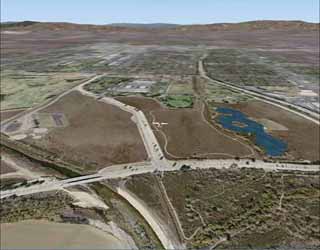
Next we overfly the Sepulveda Flood Control Basin. It is usually dry, except during infrequent but dramatic flood episodes. Most of the time it's used for different recreation activities and it even has a little wildlife reserve.
In the Pattern
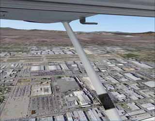
A little later we are already flying along the downwind leg. Straight and level at the traffic pattern altitude of 1.800ft and a heading of 340 degrees. Van Nuys airport is beautifully in sight to our left. Our speed is still 90 KIAS, which is perfect for traffic pattern operations in a SP 72.
Abeam the numbers of RW 16L we make our position report and tower gives us our landing clearance: "Cessna 330DG, you're number one, wind is 220 degrees at 4 knots, cleared to land RW 16L". Now we set our flaps to 10 degrees and decelerate to 80 KIAS. As soon as we reach 80 KIAS we start our descent.
When the approach end of the RW is approximately 45 degrees behind us we start our 90 degree left turn for the base leg. We set flaps to 20 degrees and slow down to 70 KIAS. While on the base leg we visually clear the final approach area. We nearly have to make no power adjustments. Everything is just fine.
Soon its time for our last 90 degree left turn to final. On final we set full flaps and reduce to 65 KIAS. RW 16L has a displaced treshold. So we take care not to land in the area that is marked by arrows. On short final we gradually slow down to our landing speed of 60 KIAS. Nothing suspicious - everything is OK. Otherwise we are prepared to make a go around immediately.
Landing
Just a few feet above the runway we take back power and pull up a bit to reduce the sinkrate for a perfect flare ;-). For a moment it seems as if the airplane does not want to touch down but then it settles on the runway.
We gently apply breaks and leave the runway at exit 10E. After we report "runway vacated", tower hands us over to ground. "Van Nuys ground, good afternoon, Cessna 330DG, clear of RW 16L at 10E request taxi to Skytrails Aviation" And ground: "330DG, good afternoon Sir, taxi to parking via Echo". Now, that' easy. We taxi down all the way via Echo, refill our tanks and shut down. Then we head for a good juicy burger and some cold drinks.
Congratulations! "Flight completed", as the chief uses to say ;-)
|