Welcome to BSSMM, the moving map utility for Microsoft (c) Flight Simulator FS9 and FSX.
BSSMM features VFR and IFR charts. On top of that you get optional overlays for NOAA weather radar,
WikiMapia maps and an AI/multiplayer traffic radar.
BSSMM is easy to use and gives you the ultimate level of situational awareness in both VFR and IFR environments.
The following screenshot shows a typical use of BSSMM in VFR chart view.
The aircraft symbol in the center of the map always shows your position and heading in FS.
The map beneath the aircraft symbol moves as you fly. So you know exactly where you are and where you're heading at.
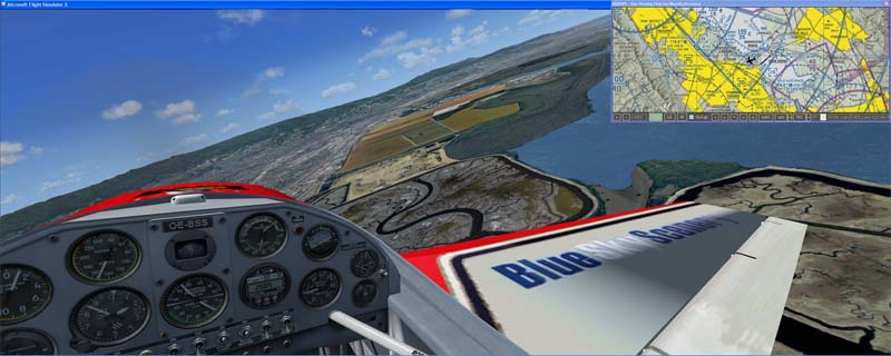
Fig.1 Moving Map
Important Notes
BSSMM works in US airspace only!
BSSMM and all information within this document is strictly for simulation use for entertainment purposes only!
BSSMM downloads charts and weather data from the internet automatically.
It is your responsibility to check the transferred data volume and to keep within the limits of your internet account!
Requirements
BSSMM reads data from FS via FSUIPC by Pete Dowson.
FSUIPC is available at http://www.schiratti.com/dowson.html. You just need the freeware version.
When FS loads FSUIPC for the first time you have to accept it to run as a trusted component.
BSSMM needs your computer to be connected to the internet to download chart and weather data.
Furthermore BSSMM needs .NET runtime 2.0 from Microsoft available at
http://www.microsoft.com/downloads/en/details.aspx?FamilyID=0856eacb-4362-4b0d-8edd-aab15c5e04f5&displaylang=en.
Installation
Just extract the content of the BSSMM.zip to any location on your harddisk. You should get a directory BSSMM containing
the program BSSMM.exe, a couple of .png's and this document. For convenience, you might add a shortcut to BSSMM.exe to your desktop.
Running BSSMM
BSSMM runs as a standalone application outside of FS. No modifications to FS are necessary. However you'll have to
run FS in windowed mode to prevent any windowing problems.
If you run FS at an elevated priviledge level (e.g. as admin), then you have to run BSSMM at the same
priviledge level. Otherwise it can't read data via FSUIPC.
Make sure to disable the "pause on task switch" option in FS. Otherwise FS pauses when you click into BSSMM.
After you start BSSMM.exe it will initialize and download the chart data around your current aircraft position. This may take a few moments.
If FS is not running, you'll get an error message and the moving map will center at San Francisco Intl. (KSFO).
You'll also get an error message if the chart services can't be reached. Furthermore you might get an error message if you fly close to the edge of US airspace.
In this case just click OK and continue. All errors are written to a file "errorLog.txt".
Description of Buttons and Functions
Zooming
The "+" and "-" buttons zoom in and out of the displayed chart.
The adjacent box indicates the current zoom level.
Different chart views have different available zoom levels.
VFR Chart View
The "VFR" button selects the VFR chart view which displays real world FAA sectional and terminal area charts.
They provide useful information for pilots navigating under VFR (visual flight rules),
like landmarks identifyable from altitude, airspace classes, radio frequencies, airports, terrain elevations etc.
For a detailed description of FAA aeronautical charts go to
http://aeronav.faa.gov/index.asp?xml=aeronav/applications/digital/aero_guide.
BSSMM caches all downloaded data into a subdirectory "Cache" within the directory BSSMM.
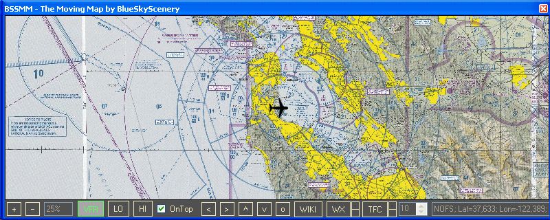
Fig.2 VFR Chart View
IFR Low Altitude Chart View
The "LO" button selects the IFR low altitude chart view which displays enroute low altitude charts.
They provide useful information for pilots flying under IFR (instrument flight rules) at altitudes of 18.000ft and below,
like navaids, fixes, V airways etc.
The highest zoom level in this view is 50%.
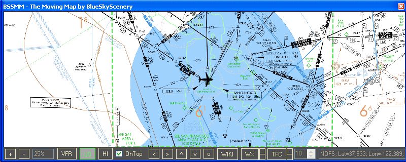
Fig.3 IFR Low Altitude Chart View
IFR High Altitude Chart View
The "HI" button selects the IFR high altitude chart view which displays enroute high altitude charts.
They provide useful information for pilots flying under IFR (instrument flight rules) at altitudes above 18.000ft,
like navaids, fixes, J airways etc.
The highest zoom level in this view is 50%.
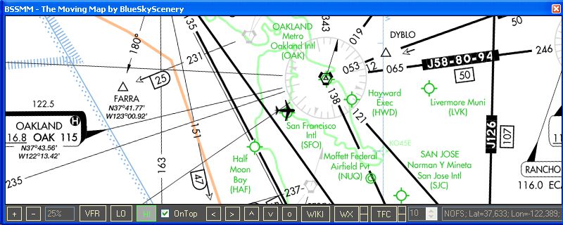
Fig.4 IFR High Altitude Chart View
Keeping the BSSMM window on top
Checking the "On Top" checkbox keeps the BSSMM window on top of all other window - e.g. the FS window.
This is very useful, and hence the default.
Scrolling
The arrow buttons "<", ">", "^" and "v" scroll
the chart away from the current aircraft position.
This is useful if you want to peek ahead without enlarging the map window. After you have seen, what you
wanted to see just press the "o" button to recenter the chart on the current aircraft position.
WikiMapia Overlay
The "WIKI" button adds a WikiMapia overlay to the selected chart view. This overlay shows cities, roads and
general points of interest. The higher the zoom level (up to 6400% in VFR chart view), the more details you'll see.
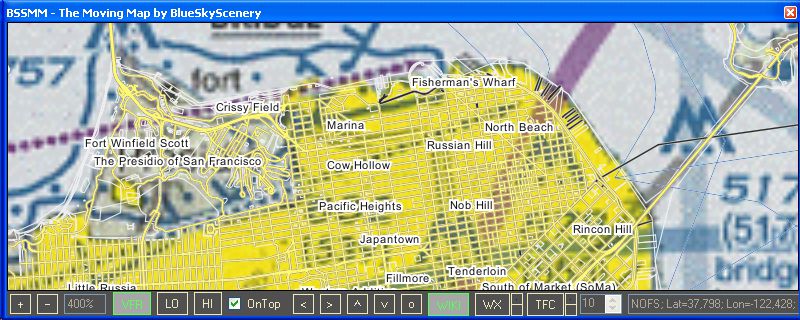
Fig.5 WikiMapia Overlay
Weather Radar Overlay
The "WX" button adds a weather radar overlay to the selected chart view.
This overlay shows current real world weather radar images from NOAA (NEXRAD).
So you have to fly with real world weather to see a correlation with FS weather.
Furthermore the weather radar will not correlate 100% to what you see in FS. The better
your weather program, the better the correlation.
The little buttons next to the "WX" button modify the transparency of the WX layer.
The colors of the radar returns range from cyan/blue (weak returns) over green and yellow to red/magenta (extreme returns).
Typically light precipitation occurs in the greens, getting moderate in the yellows and heavy/extreme in the reds/magentas.
For more information about the NOAA weather radar go to
http://www.srh.noaa.gov/radar/radinfo/radinfo.html.
BSSMM updates the weather radar images periodically every 10 minutes.
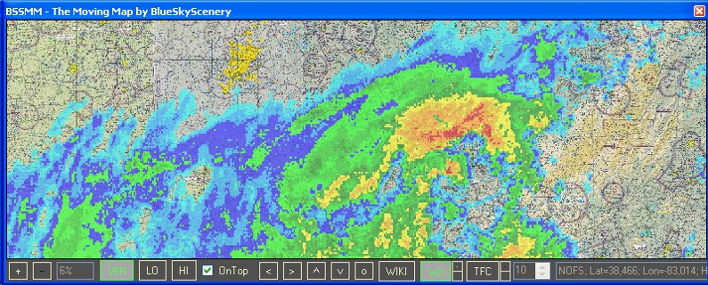
Fig.6 Weather Radar Overlay
Traffic Radar Overlay
The "TFC" button adds a traffic radar overlay to the selected chart view. BSSMM takes the traffic data from
FSUIPC. This works for both AI and multiplayer traffic. If you are flying in an online network,
make sure that your network client (e.g. SquawkBox) injects the multiplayer traffic data into FSUIPC. The little buttons next to
the "TFC" button modify the level of detail shown. The standard level shows heading, callsign, indicated altitude in 100'dreds of feet
together with a climbing(^) or descending(v) symbol if rate of climb/descent is greater/less than 500ft/min and ground speed.
The numeric up/down control controls the radar range (10nm-100nm). The radar range is displayed as a green circle on the map.
Higher values cost slightly more performance.
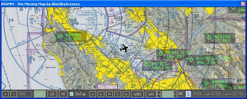
Fig.7 Traffic Radar Overlay
Credits
I'd like to thank all companies and organizations that make valuable aviation information available on the internet for free:
- FAA.gov for providing VFR and IFR charts
- iflightplanner.com for providing chart services
- NOAA.gov for providing weather radar data and
- WikiMapia.org for providing general map services
And special thanks to my beta testers Joop, Enno, Jan and John for their valuable time, patience and input!
Legal Information
This package is freeware for non-commercial use in Microsoft (c) Flight Simulators FS9 and FSX only.
It is freeware for personal use purposes only.
You may not use this package or any parts of it in a commercial environment without written permission
from BlueSkyScenery.
The copyright to this package, code, binary, textural and pictorial files
remains held by BlueSkyScenery.
Reverse engineering by decompilation or any other method is strictly forbidden.
BlueSkyScenery retains full legal rights to protect
the ownership and distribution of all information contained within this package.
No harm is intended or expected by this package.
The use of this package is entirely the risk of the user
or persons in charge or using this product.
Any risks of any form are entirely the responsibility and liability
of the user, users or persons who use or download this package.
BlueSkyScenery accepts no liability or responsibility for any damage or harm to persons
or material goods as result of this package.
Any costs relating to any damage or claimed damage is the sole responsibility of the user.
No editing of any portion of the package is permitted without specific authorised written permission by
BlueSkyScenery. This includes removal or addition of anything to the package.
Ignorance of this document or of its interpretation is not sufficient grounds
for exception to it and its legality.
BlueSkyScenery does not guarantee any fitness of this package for any purpose and does not accept any warranties or liabilities.
Unauthorized selling of this package or any parts of it or adding it or any parts to a payware product is
prohibited and will be prosecuted.
BSSMM is strictly for simulation use for entertainment purposes only.
We cannot guarantee the currency of the data provided by the used chart and weather services.
Hence BSSMM MUST NOT BE USED for real world training or flight planning.
Furthermore the chart and weather services are provided by third party companies and organizations (iflightplanner.com, WikiMapia.org and NOAA.gov).
Termination or changes of these services is at their discretion and might disrupt the functionality of BSSMM at any time.
BlueSkyScenery is by no way responsible for any cost resulting from the use of this programm, especially
for any costs caused by the internet data transfer of BSSMM.

|